By Bruce Haulman and Terry Donnelly
During this 2020 COVID-19 pandemic, while we are all sheltering-in-place, islanders look forward to the time we can return to our isolated back roads, forest trails, and beaches where we can once again experience the island’s spectacular natural beauty. Two of the most popular beaches islanders look forward to visiting are Point Heyer and Point Robinson. These points share a common ecological heritage but have diverged significantly in the ways we have treated them.
Point Heyer, better known to islanders as KVI Beach after KVI Radio purchased the sand spit and built a tower on it in 1936, and Point Robinson, where the lighthouse stands, were named by Charles Wilkes of the American Exploring Expedition after one of his quartermasters, Henry Heyer, and one of his crew members, John Robinson.
Both points were originally sand spits surrounding tidal salt marshes. In the ecology of Puget Sound, salt marshes are an important ecosystem for migrating birds, for a variety of sedges and grasses, and for the many species of shellfish, crab, and fish that utilize the marsh’s shelter.
Both of these sand spit marshes developed as a result of thousands of years of deposits from the erosion of the bluffs surrounding them. These areas are called drift cells and contain three elements. Those are 1.) steep erosional bluffs, 2.) a transit zone of depositional beaches, and 3.) a convergence zone or deposition area where sediments settle to create a sand spit. Point Heyer is the convergence zone for two drift cells, one running south from Vashon Landing to the point, the other running along Ellisport from the west. Point Robinson is also the convergence zone for two drift cells, one running north along the east side of Maury Island from Piner Point, the other running along the north shore of Maury west from Portage.
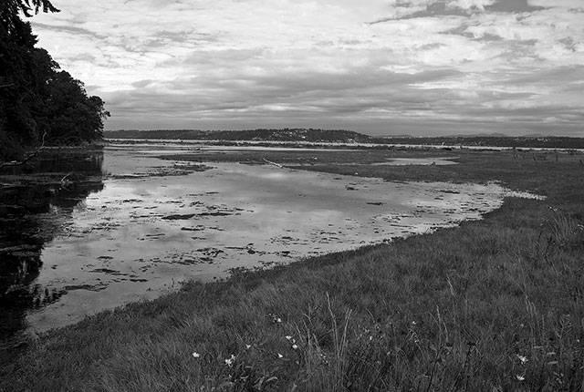
The primary Point Heyer Drift Cell is 2.5 miles long and runs from Vashon Landing to Point Heyer (KVI). It is “the only complete, intact, highly functioning drift cell in King County” according to the U.S. Geological Survey. Point Heyer (KVI) forms a 78-acre spit with ¾ miles of beach and bluff and the only substantial salt marsh remaining in the mid-Puget Sound region.
Originally, Point Heyer and Point Robinson looked very similar. The salt marsh at Point Heyer (KVI) opens to the west and the salt marsh at Point Robinson opened to the north. When the Lighthouse Service purchased the point to build a fog signal and then later a lighthouse, the salt marsh at Point Robinson was doomed. The fog signal was built in 1885, and then in 1894 when an open light tower was built, the marsh began to disappear. A bulkhead was built across the marsh to retain fresh water for the steam fog signal, beginning the end of the marsh. When the current lighthouse was built in 1915, the marsh was partially filled in to stabilize the point, and in the 1930s by washing down the slope behind it. This eliminated an important salt marsh ecosystem from the island and created the meadow that today occupies the site of the original salt marsh.
The two photographs above show the Point Robinson meadow and the Point Heyer (KVI) salt marsh as they are today. Together, these photographs show what the Point Robinson marsh would have looked like, had it not been filled. Progress has its costs. We gained a lighthouse and a park, but we lost a major salt marsh ecosystem.
Bruce Haulman is an island historian and Terry Donnelly is an island photographer.


