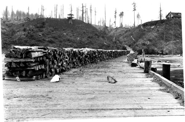
The first dock at the north end of Vashon, like most of the docks on Vashon, was built for Mosquito Fleet steamers, and only later would it be developed for automobile traffic. The Mosquito Fleet is the name given to the steamers that moved people and goods across Puget Sound from the early 1890s into the 1920s and were so numerous that they often seemed like a swarm of mosquitoes descending on Seattle and Tacoma.
These Mosquito Fleet steamers were powered by steam engines that largely burned wood to heat the boilers that drove the engines. A 1901 photo of the north-end dock shows the typical stacks of cordwood that graced every dock in the region. The Flyer, one of the fastest steamers in the fleet, typically burned about one cord of wood for every 10 miles she traveled. Making four 64-mile round-trip journeys between Seattle and Tacoma each day, the Flyer would typically burn about 25 cords of wood each day. At this rate, in a year, Flyer would burn about 5,500 cords a year. No wonder the hillside behind the dock had few trees standing.
The introduction of gasoline and diesel powered engines in the 1910s and 1920s replaced the need for firewood, but by then, much of Vashon and the Puget Sound region had been heavily logged to supply the Mosquito Fleet, the building needs of a rapidly expanding population and the demand for dimensional lumber throughout the West.
The road up the hillside in the 1901 photograph, which was the main access to the dock at that time, is not Vashon Highway, but 103rd Avenue, the road that now leads to the parking lot. The original dock was slightly to the east of the current dock, an extension of what is now the La Playa restaurant parking area.
The main Vashon Highway that carries most of the traffic today was not built until later in the 1920s, after King County rebuilt the dock slightly to the west and initiated automobile ferry service to downtown Seattle from the new dock in 1919. Once this ferry service was started, it quickly eclipsed Vashon’s first automobile ferry— which ran from Portage to Des Moines. That route was closed in 1921, since it was more convenient to go directly to downtown Seattle from the north end than to go to Des Moines from Portage and then drive the new brick Seattle-Des Moines highway to downtown.
The 2009 photo shows the same view, but with a lot more trees, the road paved and the expanded automobile dock to the right. The beach has been armored and filled to make possible the houses and restaurant that now occupy this area.
— Bruce Haulman is an Island historian. Terry Donnelly is a nationally recognized landscape photographer.


